Before really diving into GPS navigation, especially with a focus on backcountry travel, there is a foundation of basic navigation skills and terms that need to be covered. Historically most people have had a solid background in map reading, which is very important when using a GPS unit. In the last decade or so there has been a shift, due to technological advances, away from paper maps to other types of navigation. These new types of navigation are electronically based, often using GPS technology. Examples of these technologies are smartphone applications (ie Google Maps) and automotive GPS systems (Garmin Nuvi series of units and GPS systems integrated into the car from the factory). Both of those examples end up removing the user from much of the navigation process. Instead of paying attention to the road you are on, the number of miles you have been traveling it, and looking for your next road (often by the name of the road), your navigation process has been reduced to following a series of prompts. It’s an effective way of getting where you want to go, but often you lose track of where you actually are during the process. I’m going to cover basics of map reading, and the technical terms associated with that process in this article. This is important since many of these terms will transfer over to the use of a GPS unit. A GPS unit is, at it’s most basic, is an electronic map that also shows your current location.
General Map Terms
If you have used paper maps in the past, much of the following will be a review. If your map using skills are rusty or limited, this will be a good refresher and might even introduce new things that you hadn’t encountered in the past.
Legend
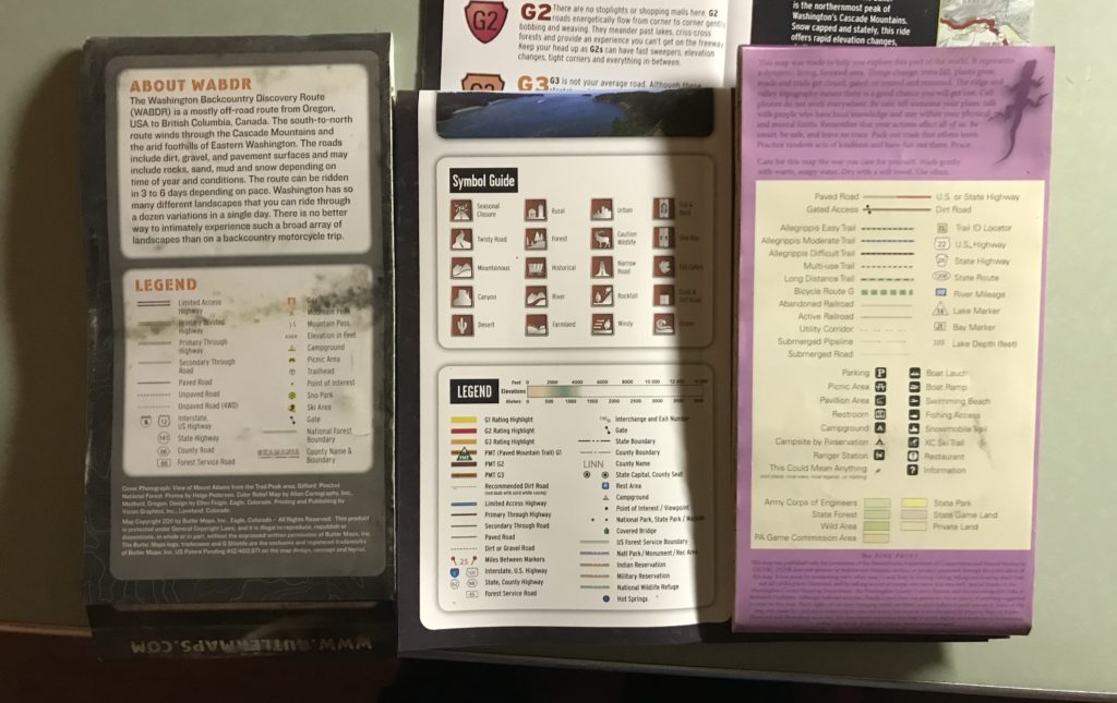
The legend of a map is often the most important, and probably the most overlooked 6 square inches on a paper map. This section will explain and decode the meaning every line type and symbol found on the map. There are some universal symbols, a tent is a campsite, a road with a number in an interstate sign shape is an interstate highway, etc those things generally remain the same. Dirt roads, hiking trails, 4×4 drivable roads, ORV (Off-Highway Vehicle) trails, are where things start to get fuzzy without referring to the legend. Generally all of the above will be marked with some sort of broken line, often different colors or highlighting colors will sort out the difference. This system is not universal, failing to reference the legend can lead to riding a motorcycle down a hiking trail. Doing so can lead to tickets or just causes general ill will between different types of public land users.
Above is an example of three different legends on some maps I had handy. From left to right there is the Butler Map for the Washington Backcountry Discovery Route, the next is the Butler G1 Map of Washington State, and the third is a Purple Lizard trail map for the Raystown Lake area of Pennsylvania. Many of the symbols are the same, but there are many differences. These differences are due to the different type of activity the targeted map user would be doing. Butler Maps sells primarily to motorcyclists and other off-road recreational motorized vehicle users. Any maps focus will be on terrain features the map user would find useful. In this case things like hiking or bicycling trails are skipped. Purple Lizard Maps is a regional map maker, which I highly recommend you check out there maps if you are in central Pennsylvania. They produce a much more general focus outdoor map, covering a much smaller geographic area. This encompasses ORV use, as well as hiking, bicycling, horseback riding, and just about everything else you can think of doing on public lands. The Purple Lizards maps highlights the different state and federal parks, and all of the different trail systems for each type of land user. These are just a few examples I had handy..
There are many other types of maps you are likely to use, and groups that are producing them. Federal agencies such as the United States Geological Survey (USGS), United States Forest Service (USFS), and state level land management agencies often with titles such as Department of Natural Resources (DNR), all produce and distribute maps. Often the same information will be found on the electronic maps used by GPS companies like Garmin. Private groups such as the American Automotive Association (AAA) and Michelin also produce road maps and atlases. Most local off-road motorcycle clubs, and other outdoor groups will produce maps for local trail systems, though they often are of lower levels of detail.
With so many map producers, and differences in focus, it is easy to see why checking the legend is so important. If you are just moving between the same producer of map, a handful of USGS quadrant maps as an example. It is unlikely you will need to recheck the legend on each map. On the other hand if you are focused on one area, and are using a USGS map, a Butler Map, and a Purple Lizard map, it is good to double check the legend when shifted between maps to avoid any confusion on the maps message.
Scale
The scale of the map is also very important, without knowing this key piece of information you would not know if one inch on the map relates to a mile or 100 miles in the real world. The scale of the map can be dictated by a few factors. On one end of the spectrum we have maps for a very specific area or event, the scale will generally be dictated by the size of paper the map is printed on. Think of the map you get at a ski area that shows all of the runs on the mountain. Regardless of the actual size of the ski area, from a small local mountain with a dozen runs in New England or a huge resort with over 100 runs in Colorado the map is almost always on the same size sheet of paper. This works since you will only use one map at a time, the difference of scale between mountains doesn’t cause any issues since you are never going to reference between two maps. On the other end of the spectrum you have the USGS topographical maps for the United States. This map system is designed to be used to cover any amount of land, using as many maps as required to cover the target area. The USGS uses two different scales, 1”:100,000” (aka 100k or area map) and 1”:24,000” (aka 24k or quad map). The US military and the rest of the metric world uses different scales, I don’t use those frequently enough anymore to quickly reference there common scales.
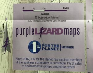
The scale is found on the the map itself, it calls out the scale and shows a line denoting what the scale is. Above is examples from both Butler Maps and Lizard Maps of the scale as found on the map. This is handy both for when using a map for planning a trip or when on the trail. If you are being fancy a divider can be used to gauge a distance from the scale and compare it between the two points you are trying to go between. On the trail I will generally use my fingers to do the same thing, it’s not the most accurate, but generally good enough for rough trail math. Often you will also find a second scale on any detailed map inserts that have zoomed in on a particular area of interest.
Closing
This article is really just a fast refresher to paper maps, a primer for you to revisit a resource you may have forgotten. Clear off a table, spread out a map, and spend some time looking at it and actually reading it. If you are interested in learning more about outdoor navigation using a map a compass I recommend the book “Wilderness Navigation” from The Mountaineers Books (ISBN: 978-0-89886-953-8), you should be able to find this at any bookstore or outdoor supply store. My copy of this book tends to get referenced every spring as I start to prepare for a new season of adventure. If you spent some time in the military (or the Boy Scouts), like I did, grab that dusty old copy of the “Guidebook for Marines” or whatever your branches equivalent was. I am sure there is some interesting reading in there too. I strongly believe that paper maps are still an essential tool for navigation. I cannot recall the number of times I have used one side by side with my GPS unit in the field or had three, or more piled on my desk with Garmin Basecamp pulled up on my computer creating the rides for a motorcycle event or even a personal weekend trip.
Good luck out there, have fun, and Godspeed!
-Eric Archambault
More GPS Information Below
How to load tracks for your next adventure
Terms and Vocabulary for Navigation – Part One
Terms and Vocabulary for Navigation – Part Two
Navigating with Tracks – Tips & Tricks


